
DART – A mobile tracked robot
Introducing our inaugural robot– a versatile tracked robot with a user-friendly undercarriage design that can be effortlessly constructed by anyone with access to a 3D printer. We provide comprehensive explanations of each component, detailed instructions for seamless connections, and a step-by-step guide on how to assemble this innovative 3d printed robot. Whether you’re a seasoned robotics enthusiast or a curious beginner, our user-friendly approach ensures that building your own tracked robot is an accessible and enjoyable experience. To aid you on this exciting journey, we’ve created a detailed YouTube video, demonstrating every step of the process. Click the link below to embark on the adventure of constructing your very own DART tracked robot and unleash the potential of robotics in the palm of your hands.
For step-by-step instructions on how to build a DIY DART crawler please visit the @DigInt_Tech channel YouTube
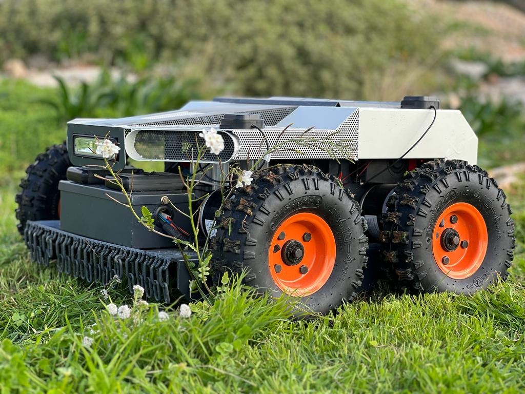
KNOX UGV-Electric 4 wheeler Grass cutter robot + drone
Introducing KNOX UGV the Electric-Drone /Robot . A cutting-edge 4-wheeled electric grass cutter cutter designed for seamless adaptability, offering both manual operation and programmable waypoint navigation.
KNOX harnesses the power of our advanced GNSS RTK control systems, achieving centimeter-level accuracy. Specifically crafted to revolutionize grass cutting, it comes equipped with additional features tailored for various agricultural practices. Further insights into design specifications and a step-by-step guide on assembling KNOX will be unveiled during our upcoming workshop.
Watch KNOX in action on @DigInt_Tech channel YouTube
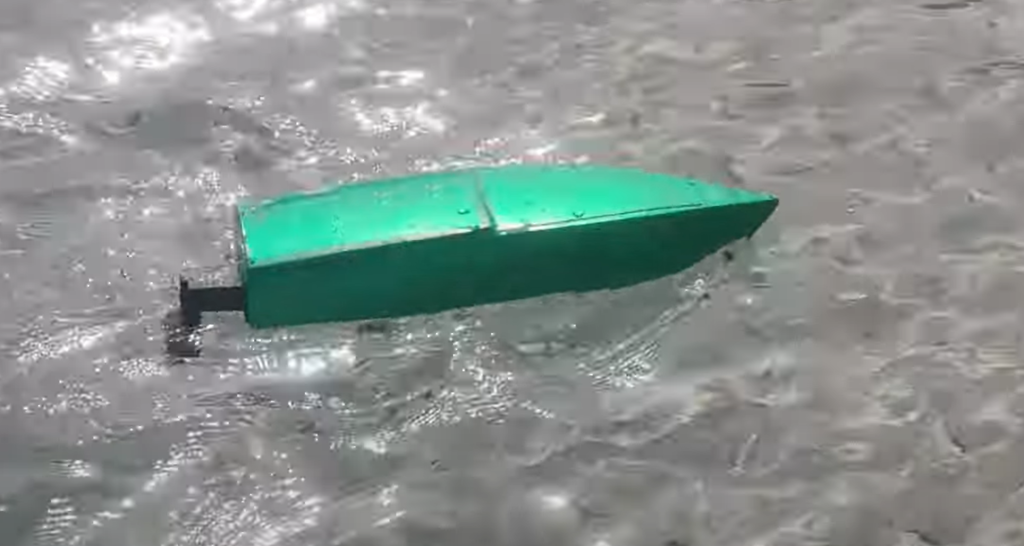
REEF – 3D Printed Boat (Building the body)
Introducing REEF, the cost-effective boat-drone that stands out for its simplicity, affordability, and unique 3D printing construction. This versatile aquatic companion not only provides manual control but also introduces an exciting feature – the ability to program routes. Users can easily define a course, and REEF, with its 3D printed design, will execute the specified movements. This innovative capability adds a layer of convenience, enabling enthusiasts to plan and control precise journeys for the boat. With its budget-friendly build and seamless operation, REEF is a standout choice for those keen on adventurous aquatic experiences. For detailed, step-by-step instructions on 3D printing and assembly, please press the provided link and visit the accompanying YouTube video.

REEF – Converting to Unmanned Surface Vehicle (USV) with Google Maps Waypoint
REEF, the cost-effective Unmanned Surface Vehicle (USV) or boat-drone which is simple to do and inexpensive, not only offers manual control but also introduces an exciting capability – programming through Google Maps. Users can harness the power of waypoints in the Google Maps interface to define a route, and the REEF boat will autonomously execute the specified movements. This advanced feature adds a layer of convenience and automation to aquatic exploration, enabling users to plan and execute precise routes for the boat. With its budget-friendly construction and seamless integration with Google Maps for waypoint-based programming, REEF stands out as a versatile and accessible option for enthusiasts interested in autonomous aquatic adventures. For detailed, step-by-step instructions on building, please refer to the provided link and accompanying YouTube video.

Introduction to GNSS. A Short Explanation
The “Introduction to GNSS” explanation lesson provides a comprehensive overview of the evolution of satellite navigation systems, focusing on the development of Global Navigation Satellite Systems (GNSS) and Real-Time Kinematic (RTK) technology. Beginning with the launch of the Sputnik satellite in 1957, the lesson traces the progression from the Navy Navigational Satellite System to the establishment of the Global Positioning System (GPS) in 1983. The presentation delves into the global expansion of GNSS, including GLONASS, Galileo, BeiDou, and QZSS, each offering unique orbital configurations and services. The lesson emphasizes the importance of combining signals from different constellations for precision, with a spotlight on the European Galileo system. RTK is introduced as a key technology for achieving centimeter-level accuracy in drone navigation. The presentation details the process involving a stationary GNSS base station and its implications for applications like precision agriculture.

A warm welcome from diginto.tech co-founder
Steve Zerafa, co-founder of Diginto channels, extends a warm welcome in a short video introducing the workshop focused on drones & geo-robotics. The goal is to democratize drone, robotics and unmanned vehicles knowledge, making it accessible to everyone, whether experienced or new to the drone and robotic world. Steve invites you to Subscribe to Diginto for upcoming tutorials on building and using drones and robotics showcasing cost-effective solutions for various purposes, hobby or commercial. Engage with the community, share ideas, and look forward to a series of videos exploring different types of drones / robotics / unmanned vehicles.
DigInto Tech promises an exciting journey through the world of drones, inviting viewers to enjoy, engage, and embark on the adventure of drone-robotic design and building together.